Exploration and Analysis of Hidden Fault Identification Methods in the Ordos Basin
-
摘要:
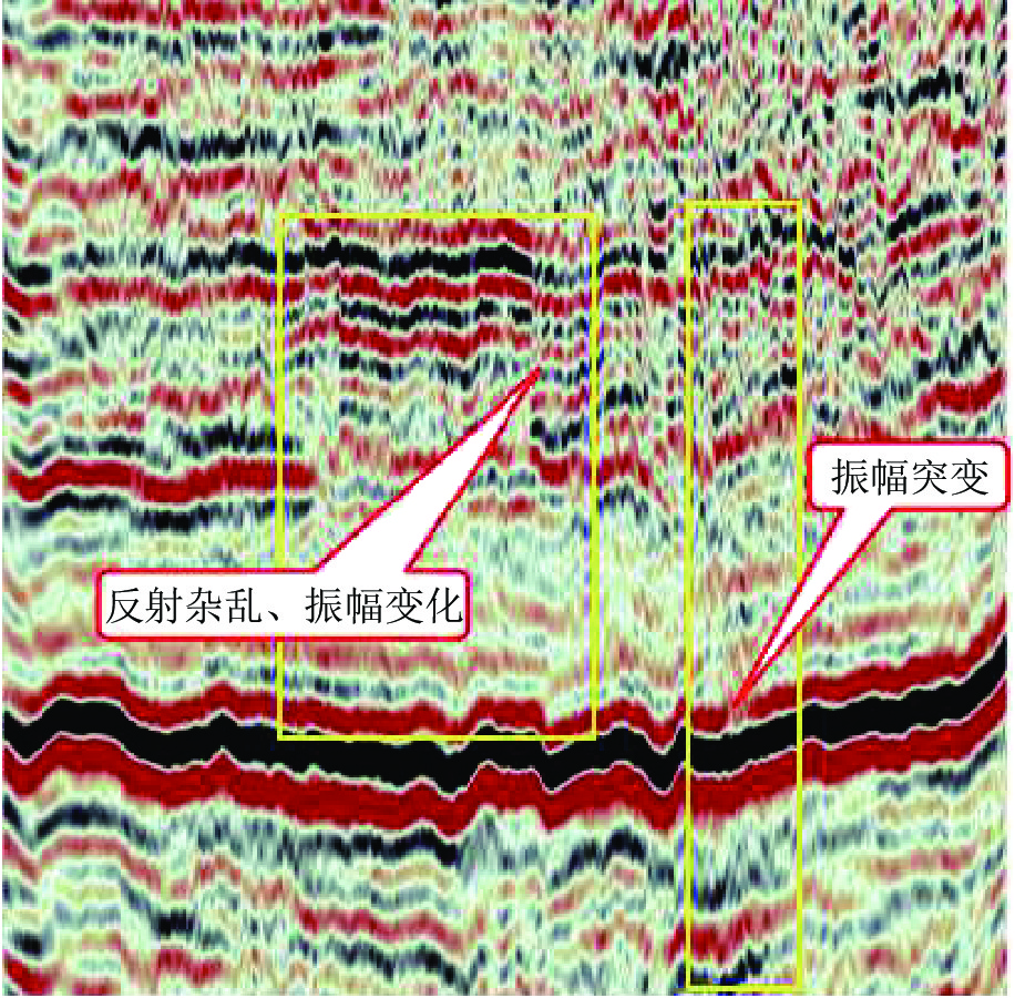
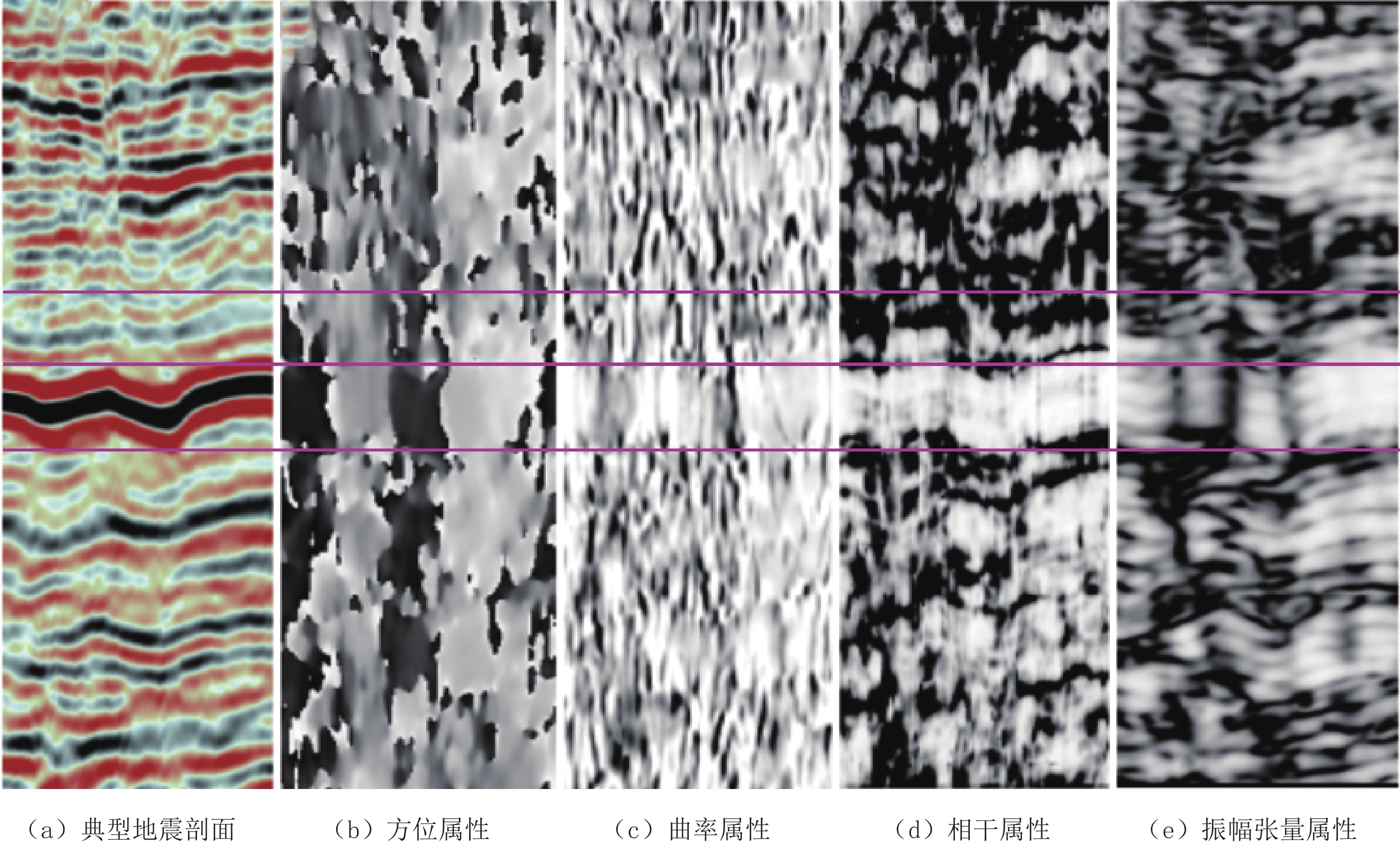
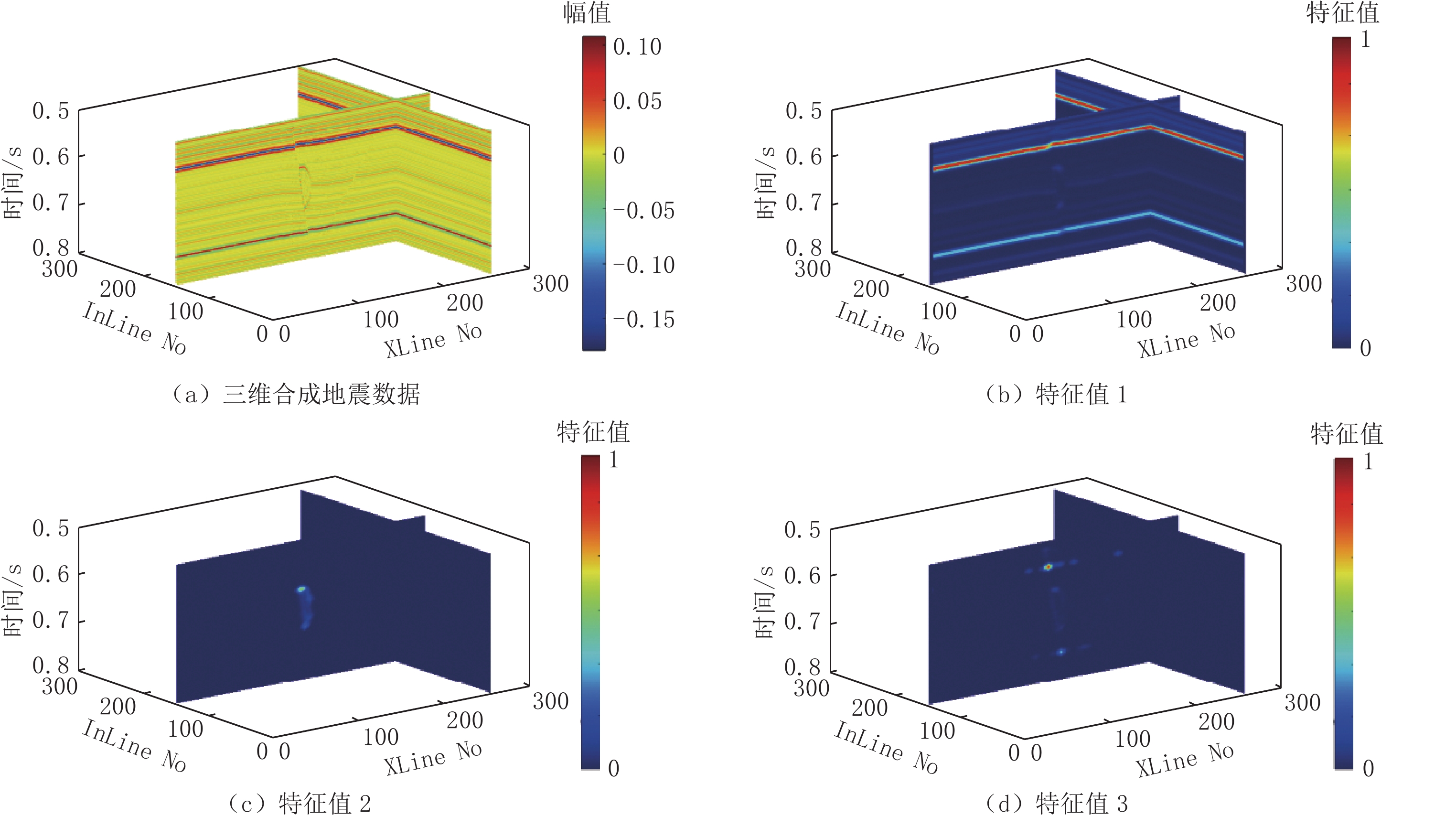
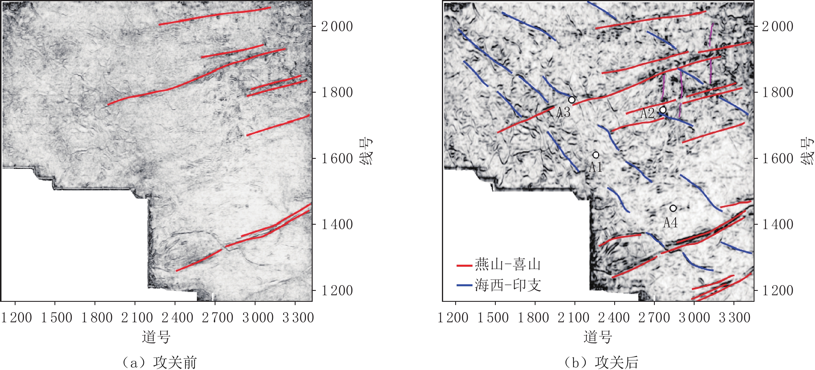
近年来,为进一步加大鄂尔多斯盆地油气资源勘探开发力度,地震勘探由二维向三维规模转变,三维地震随着处理解释技术进步,资料品质逐年提升。陇东地区上古生界断裂属隐蔽性低序级,断距小(<5 m)、多数钻遇无明显工程异常,在地震剖面上表现为以扭曲为主、同相轴无明显错断,识别难度大。结合实钻与地质认识综合分析认为该区断裂在控储、控藏、控水侵方面突出,有效识别该区断裂对于指导下步勘探尤为关键。目前断裂识别以相干、曲率等常规地震属性为主,存在断裂属性差异大、识别精度低、期次确定难等问题。鉴于此,依托典型三维资料,通过地震信号分解、正演模拟、残差分析、振幅张量计算、空间属性约束断面建立等手段,解决隐蔽性断裂识别难问题。通过本次方法攻关,断裂识别结果与油气地质认识及实钻情况基本相符,初步建立一套针对隐蔽性断裂识别的方法技术流程,为指导类似地区断裂高精度识别奠定技术基础。
Abstract:Recently, in order to strengthen the exploration and development of oil and gas resources in the Ordos Basin, seismic exploration has changed from a two-dimensional to a three-dimensional (3D) scale. With the progress of 3D seismic processing and interpretation technology, the data quality has improved each year. The Upper Paleozoic faults in the eastern Longdong region are of hidden low sequences with small fault spacings (<5 m); no obvious engineering anomalies exist in most drilling cases. The faults are characterized by distortion and no obvious dislocation in the in-phase axis in the seismic section, which is difficult to identify. Together with the comprehensive analysis of actual drilling and geological knowledge, it was concluded that the faults in this area were prominent in controlling reservoirs and water invasion. Effective identification of the faults in this area is critical in guiding further exploration. At present, the fault identification is based mainly on conventional seismic attributes, such as coherence and curvature; there are some issues, such as large differences in fault attributes, low identification accuracy, and difficulty in determining the duration. The difficulty in identifying hidden faults was solved by means of seismic signal decomposition, forward modeling, residual analysis, amplitude tensor calculation, and section construction constrained by spatial attributes, relying on typical 3D data. The fault identification results using this method are basically consistent with the oil and gas geological knowledge and the actual drilling situation. A preliminary set of methods and technical processes for the identification of hidden faults has been established, which lays a technical foundation for guiding the high-precision identification of faults in similar areas.
-
Keywords:
- Ordos basin /
- fault identification /
- seismic signal /
- forward modeling
-
锥形束CT(cone beam computed tomography,CBCT)检查是以锥形X射线束围绕受检者受检部位旋转1周后成像的方法。通过锥形束扫描方式避免了周围结构重叠的影响,提高了三维空间分辨率,同时大大减少了扫描剂量,且明显低于普通螺旋CT[1-3]。
CBCT一方面能够全面观察被检部位内部结构,获得所用信息进行容积重组,形成更精确分辨率的图像;另一方面具备独特的金属伪影校正技术及各向同性空间分辨率优势,目前在口腔医学临床中得到广泛应用[4-5]。
在临床实际应用中,口腔CBCT检查作为一种3D成像方法,所得图像不仅局限于口腔牙齿、牙槽骨显像,也包含了周围组织结构的显像。在CBCT检查中这些周围结构的显示情况如何,能否检出耳鼻喉相关组织的疾病,如口腔疾病累及邻近上颌窦的病例,及口腔疾病合并常见的鼻窦及口咽疾病[6],目前尚未见到报道。
本研究旨在探讨口腔CBCT检查中耳鼻喉相关组织结构的影像学表现,为临床减少不必要的漏诊提供理论依据。
1. 资料与方法
1.1 一般资料
回顾性分析2019年7月至2020年5月在医院完成口腔CBCT检查的患者300例,其中男161例、女139例,年龄范围8~79岁,平均年龄(41.9±16.0)岁。
1.2 检查方法
采用口腔颌面锥形束计算机体层摄影设备(CBCT)(imaging science international,LLC)进行扫描,扫描体位:坐位;扫描参数:管电压120 kVp、管电流5 mA,获取时间26.9 s;扫描方式:360°;视野大小:直径 16 cm、高度11 cm;分辨率25立体像素14.7 s。
1.3 图像评价
用双盲法独立评判成像图像中以上组织的解剖显示率(上颌窦、蝶窦、额窦、筛窦),并对组织结构显示情况及组织结构间成像对比度进行评分。
①物理学标准:根据患者扫描所得整体图像信噪比(signal noise ratio,SNR)评价,无法诊断为 1分、诊断明显受限为2分、诊断受限为3分、诊断不受限为4分;②解剖学标准:按照图像中鼻窦(上颌窦、蝶窦、额窦、筛窦)、咽隐窝、鼻腔及前庭、乳突解剖结构显示是否完整清楚进行评分,1分为差、2分为一般、3分为良、4分为优;③患者图像耳鼻喉相关不同密度组织(气体、骨质、液体、软组织及脂肪组织)显示及对比度评分,1分为差、2分为一般、3分为良、4分为优[7]。
1.4 统计学处理
采用SPSS 26软件对所得数据进行统计分析,计量资料用均数±标准差(
$ \bar x \pm s $ ),两组间比较采用独立样本t检验。评估者之间比较采用 Kappa一致性检验,Kappa值大于0.6认为有高度一致性。P<0.05被认为具有统计学意义。2. 结果
2.1 图像中耳鼻喉相关不同解剖结构组织的显示评估
所有检查者图像扫描规范、图像质量均符合口腔诊断要求,上下边缘层面均可见环形伪影(图1和图2)。
周围组织结构显示中两位医师评分一致性好,Kappa值最低达0.754,超过要求的0.6水平。所有图像质量好,信噪比评分大多数大于等于3分,其中乳突只能部分显示,评分3分及以上占比约50%,其中:上颌窦及蝶窦均可显示,且显示清楚,额窦及筛窦均未见显示,咽隐窝、鼻腔及前庭均可显示,且显示清楚,乳突均为部分显示,解剖结构显示为一般及良好(图3、表1)。
表 1 图像SNR及牙齿周围组织结构解剖显示评估Table 1. Image SNR and evaluation of anatomical display of tissue structure around teeth项目 A医师 B医师 平均 ≥3分/% ≤2分/% Kappa系数 感知信噪比 3.83±0.41 3.79±0.43 4# 98.7~99.0 1.0~1.3 0.754 上颌窦、蝶窦 4 4 4# 100 0 1.000 额窦、筛窦 1 1 1* 0 100 1.000 咽隐窝 3.96±0.27 3.96±0.28 3.96±0.28# 98.7~99.0 1.0~1.3 0.864 鼻腔、前庭 3.99±0.10 3.99±0.12 3.99±0.12# 99.7 0.3 1.000 乳突 2.43±0.69 2.36±0.73 2.40±0.85${}^\nabla $ 46.3~49.3 50.7~53.7 0.820 注:# vs $\nabla $、# vs *、* vs $\nabla $,P<0.05差异有统计学意义;# vs #,P>0.05差异没有统计学意义。 2.2 图像中耳鼻喉相关不同密度组织显示及对比度评估
所有图像中气体及骨质显示优良,两位医师评分Kappa值等于1,评分一致性非常好;软组织及液体组织显示差,两位医师评分Kappa值均小于0.6,评分一致性差;气体、骨质的对比度均大于等于3分,明显高于与脂肪、软组织及液体的对比度,且对比度间差异有显著意义,而气体与骨质对比度间及脂肪、软组织、液体对比度间差异无统计学意义(图3、表2)。
表 2 耳鼻喉相关不同密度组织显示及对比度评估Table 2. Contrast evaluation and display of different density tissues related to ear, nose and throat项目 A医师 B医师 平均 ≥3分(%) ≤2分(%) Kappa系数 气体 4 4 4# 100 0 1.000 骨质 4 4 4# 100 0 1.000 软组织 0.85±0.36 0.77±0.42 0.81±0.38${}^{\nabla} $ 0 100 0.535 脂肪 1 1 1${}^{\nabla} $ 0 100 1.000 液体 0.81±0.39 0.71±0.46 0.75±0.45${}^{\nabla} $ 0 100 0.543 注:# vs $\nabla $,P<0.05差异有统计学意义;# vs #、$\nabla $ vs $\nabla $,P>0.05差异没有统计学意义。 3. 讨论
CBCT因电离辐射小、精度高、显示三维空间结构,成为口腔医师进行牙齿治疗前的首选方法,在口腔正畸和种植中广泛使用[8-9]。本组所有完成口腔CBCT检查的受检者中,接收的X线辐射剂量仅为19.9 mGy·cm,远低于专家共识中对鼻窦CT检查的辐射要求,即鼻窦CT检查中CTDIvol 40 mGy,甚至低于共识中提到的鼻窦CT检查辐射剂量可能达到水平25 mGy[10]。在具体分析扫描图像中,发现所有扫描最上层及最下层图像中均出现了环形伪影,信噪比评分有所下降,为无法诊断及诊断明显受限,考虑这些伪影是扫描中X线衰减所致,但中心层面图像显示清楚,信噪比大多数评分为诊断不受限。
本研究在对口腔周围耳鼻喉相关结构的图像分析中,发现部分鼻窦显示良好,解剖结构显示清楚,部分鼻窦解剖结构显示不清。具体表现为鼻窦中上颌窦显示良好,解剖结构显示清楚。考虑因其在大体组织解剖中位于上颌骨体内,而上颌骨前表面朝前朝外构成了上牙槽、对应了牙根的位置,即上颌窦正位于上牙牙根正上方,就处于CBCT的扫描范围内。上颌窦临近牙齿的解剖位置会造成临近牙齿疾病的累及,比如在牙源性疾病中,炎性疾病(如牙龈炎)及肿瘤性疾病,如含牙囊肿、牙瘤及造釉细胞瘤等均会累及临近上颌骨或下颌骨,造成牙源性上颌窦炎[11-12]。同时,上颌窦因其解剖位置较低、自然开口与鼻腔相通位置较高且细小,黏膜与鼻腔相连,容易感染阻塞及狭窄,成为副鼻窦感染中最为常见的部位[13]。
所以,当上牙出现问题进行CBCT扫描时,图像观察除牙齿之外,还需要观察邻近的上颌骨及上颌窦情况,如含牙囊肿中邻近上颌骨的骨质破坏情况、牙龈炎时是否合并上颌窦炎,或者是否单独存在上颌窦炎。
除此之外,本组研究也分析鼻窦中位置最深的蝶窦,在口腔CBCT检查中能够清楚显示也,图像评分均达3分以上,考虑由于它位于蝶骨体内,与临近的咽隐窝、鼻腔及前庭一起,均处于上颌骨水平的解剖范围内,能够在口腔CBCT检查中得到良好显示。乳突只能部分显示,图像评分3分及以上只是占比约50%,考虑因其是从颞骨乳突部的底面突出的圆锥形突出,位于外耳道的后面和茎突的外面,部分处于下颌骨支外侧水平范围内,所以可以部分显示。另一方面,作为鼻窦的组成部分的额窦及筛窦因两者处于口腔CBCT扫描范围外,均未显示。
具体解剖表现为筛窦位于鼻腔外上方筛骨内,而筛骨位于颅骨的前基底部,处于鼻顶部,并在两个眼眶之间,额窦位于额骨的内、外侧骨皮质之间,在筛窦的前上方,位置更高,处于CBCT扫描上缘水平之外。所以在CBCT口腔检查中,除牙齿之外,我们还能观察到处于扫描范围内的副鼻窦、乳突、咽隐窝、鼻腔及前庭这些耳鼻喉相关组织的图像。
在CBCT检查低剂量的优势下,这些耳鼻喉相关组织结构能否清楚显示,即组织间图像对比度如何?本组研究继续进行了相关图像的进一步分析。
在对口腔CBCT能显示的组织结构成像中,气体及骨质显示对比度好,易于评估且评估一致性好;软组织、液体及脂肪显示对比度不佳,不易于评估,且评估一致性不佳,即鼻窦窦腔及窦壁骨质、乳突气房、咽隐窝、鼻腔、前庭含气组织结构显示清楚,但软组织间界限欠清,考虑是因为口腔CBCT属于X线成像,所以对于气体、骨、软组织显示优秀,但密度分辨率低于普通螺旋CT[14-16]。这样,一方面在CBCT口腔检查中,利用气体、骨质及软组织间良好的对比度,当含气组织发生形态改变时辅助相应耳鼻喉相关组织疾病的检出。
例如急性鼻窦炎的病理改变主要是以黏膜增生、肥厚及囊肿形成为主,并引起相应气腔改变[17];在其影像诊断中,主要依据包括了含气窦腔大小、形态改变及窦腔内黏膜增厚,所以通过良好的气体及软组织对比度,来观察窦腔形态的改变,减少急性鼻窦炎的漏诊,尽量达到对急性鼻窦炎早发现、早治疗,避免因炎症的恶化及感染扩散,引起疾病迁延不愈及并发症的发生所导致的患者生活质量下降[18]。同时通过发现窦壁骨质增厚来辅助诊断慢性鼻窦炎。
另一方面,在口腔CBCT检查中对软组织、液体及脂肪之间的对比度评估差,肌肉间隔显示不清,而无法对软组织病变进行具体测量及定性,即对耳鼻喉相关组织疾病中的怀疑肿瘤性病变者,还需进一步检查。
本组研究中的两位医师对口腔CBCT检查中耳鼻喉相关组织中的软组织、脂肪及液体之间的对比度评判中,评分一致性差,考虑这与医师之间临床经验存在差异,而对图像分析能力存在区别有关,表明临床经验的差异将影响口腔CBCT检查中耳鼻喉相关组织疾病的检出。
本次研究中也存在不足之处,对于口腔CBCT检查中已存在病变的检出及疾病的分类未进行统计及分析,将在下一步研究中完善。
4. 小结
低剂量口腔CBCT检查中对耳鼻喉相关组织中含气体组织如部分鼻窦、乳突、咽隐窝、鼻腔及鼻前庭能够清楚显示解剖结构,可以通过含气组织气腔形态及骨质改变发现口腔以外组织病变,减少临床疾病的漏诊,但对软组织结构间的对比显示不佳,对软组织病变的定性还需进一步检查。
-
-
[1] GERSZTENKORN A, MARFURT K J. Eigenstructure based coherence computations as an aid to 3D structural and stratigraphic mapping[J]. Geophysics, 1999, (5): 1468−1479.
[2] MARFURT K J, KIRLIN R L, FARMER S L, et al. 3D seismic attributes using a running window semblance algorithm[J]. Geophysics, 1998, 63: 1150−1165.
[3] RANDEN T, MONSEN E, ABRAHAMSEN A, et al. Three dimensional texture attributes for seismic data analysis[J]. SEG Technical Program Expanded Abstracts, 2000: 668-671.
[4] PEDERSEN S I, SKOV T. Automatic fault extraction using artificial ants[J]. SEG Technical Program Expanded Abstracts, 2002, 21: 512−515.
[5] QI J, LI F, LYU B, et al. Seismic fault enhancement and skeletonization: 86th Annual International Meeting[C]//SEG, Expanded Abstracts, 1966-1970.
[6] MACHADO G, ALALI A, HUTCHINSON B, et al. Display and enhancement of volumetric fault images[J]. Interpretation, 2016, 4: SB51−SB61. DOI: 10.1190/INT-2015-0104.1.
[7] 何发岐, 王付斌, 张威, 等. 鄂尔多斯盆地北缘勘探思路转变与天然气领域重大突破[J]. 中国石油勘探, 2020, 25(6): 39−49. HE F Q, WANG F B, ZHANG W, et al. Transformation of exploration ideas and a major breakthrough in natural gas exploration in the northern margin of the Ordos Basin[J]. China Petroleum Exploration, 2020, 25(6): 39−49. (in Chinese).
[8] 李潍莲, 纪文明, 刘震, 等. 鄂尔多斯盆地北部泊尔江海子断裂对上古生界天然气成藏的控制[J]. 现代地质, 2015, 29(3): 584−590. DOI: 10.3969/j.issn.1000-8527.2015.03.010. LI W L, JI W M, LIU Z, et al. Control of Boer Jianghaizi Fault on gas accumulation of upper paleozoic in northern Ordos Basin[J]. Geoscience, 2015, 29(3): 584−590. DOI: 10.3969/j.issn.1000-8527.2015.03.010. (in Chinese).
[9] 姚宗惠, 张明山, 曾令邦, 等. 鄂尔多斯盆地北部断裂分析[J]. 石油勘探与开发, 2003, 30(2): 20−23. YAO Z H, ZHANG M S, ZENG L B, et al. Analysis of the faults in the northern Ordos Basin, Northwest China[J]. Petroleum Exploration and Development, 2003, 30(2): 20−23. (in Chinese).
[10] 汪泽成, 赵文智, 门相勇, 等. 基底断裂“隐性活动”对鄂尔多斯盆地上古生界天然气成藏的作用[J]. 石油勘探与开发, 2005, 32(1): 9−13. WANG Z C, ZHAO W Z, MEN X Y, et al. Control of basement fault minor-activity on gas pool formation of upper paleozoic, Ordos Basin[J]. Petroleum Exploration and Development, 2005, 32(1): 9−13. (in Chinese).
[11] DONIAL M, DAVID C, BERTHOUMIEU Y, et al. New fault attribute based on robust directional scheme[J]. Geophysics, 2007, 72: 39−46.
[12] BAHORICH M S, FARMER S L. 3D seismic coherency for faults and stratigraphic features[J]. The Leading Edge, 1995, 14(10): 1053−1058. DOI: 10.1190/1.1437077.
[13] LISLE R J. Detection of zones of abnormal strains in structures using Gaussian curvature analysis[J]. American Association of Petroleam Geologists Bulletin, 1994, (78): l8ll−l8l9.
[14] ROBERTS A. Curvature attributes and their application to 3D interpreted horizons[J]. First Break, 2001, 19(2): 85−100.
[15] 陈双全, 季敏. 地震数据结构张量相干计算方法[J]. 石油物探, 2012, 51(3): 233−238. CHEN S Q, JI M. Structure tensor cohe-rence computation method of seismic data[J]. Geophysical Prospecting for Petroleum, 2012, 51(3): 233−238. (in Chinese).
[16] 崔正伟, 程冰洁, 徐天吉, 等. 基于构造导向滤波与梯度结构张量相干属性的储层裂缝预测方法及应用[J]. 石油地球物理勘探, 2021, 56(3): 555−563. CUI Z W, CHENG B J, XU T J, et al. Reservoir fracture prediction method and application based on structure-oriented filtering and coherent attributes of gradient structure tensor[J]. Oil Geophysical Prospecting, 2021, 56(3): 555−563. (in Chinese).
[17] 陈强, 许玉莹, 曾维望. 基于地震数据结构梯度张量属性的采空区识别方法[J]. 中国煤炭地质, 2013, 25(7): 42−47. CHEN Q, XU Y Y, ZENG W W. Goaf identification method based on seismic data gradient structure tensor (GST) attributes[J]. Coal Geology of China, 2013, 25(7): 42−47. (in Chinese).
[18] 问雪, 陈雪芳, 陈胜红, 等. 利用结构导向平滑方法解释断层[J]. 石油地球物理勘探, 2017, 52(1): 146−151. WEN X, CHEN X F, CHEN S H, et al. Faults interpretation based on structure-oriented smoothing method[J]. Oil Geophysical Prospecting, 2017, 52(1): 146−151. (in Chinese).
[19] 王清振, 张金淼, 姜秀娣, 等. 利用梯度结构张量检测盐丘与断层[J]. 石油地球物理勘探, 2018, 53(4): 826−831. WANG Q Z, ZHANG J M, JIANG X D, et al. Salt dome and fault detection based on the gradi-ent-structure tensor[J]. Oil Geophysical Prospecting, 2018, 53(4): 826−831. (in Chinese).
[20] KNUTSSON H. Representing local structure using tensors[C]//Proceedings of 6th Scandinavian Confe-rence on Image Analysis, 1989: 545-556.
-
期刊类型引用(2)
1. 杨影,魏崴,杨军. 锥形束CT在耳鼻咽喉头颈外科中的应用进展. 山东大学耳鼻喉眼学报. 2024(03): 109-115 .  百度学术
百度学术
2. 王振婷,李北,季意,张娟,杨晨,单华,刘锐. 成年人翼钩及其周围组织的CBCT影像学研究. 口腔医学. 2024(10): 728-733 .  百度学术
百度学术
其他类型引用(2)


 下载:
下载:


