Data Processing Solutions on Low Signal-to-Noise Data in Loess Plateau Area- A Case Study in Ordos Basin, China
黄土塬区低信噪比资料处理解决方案——以鄂尔多斯盆地为例
-
Abstract:
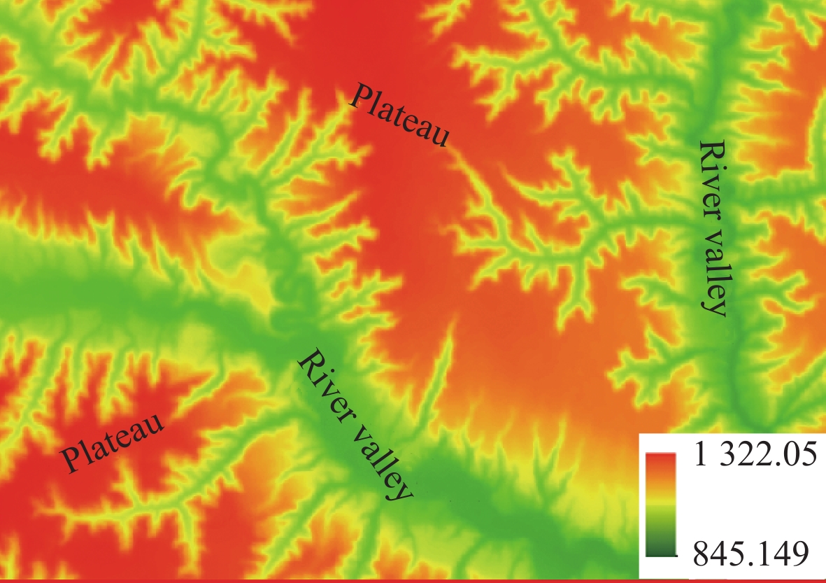
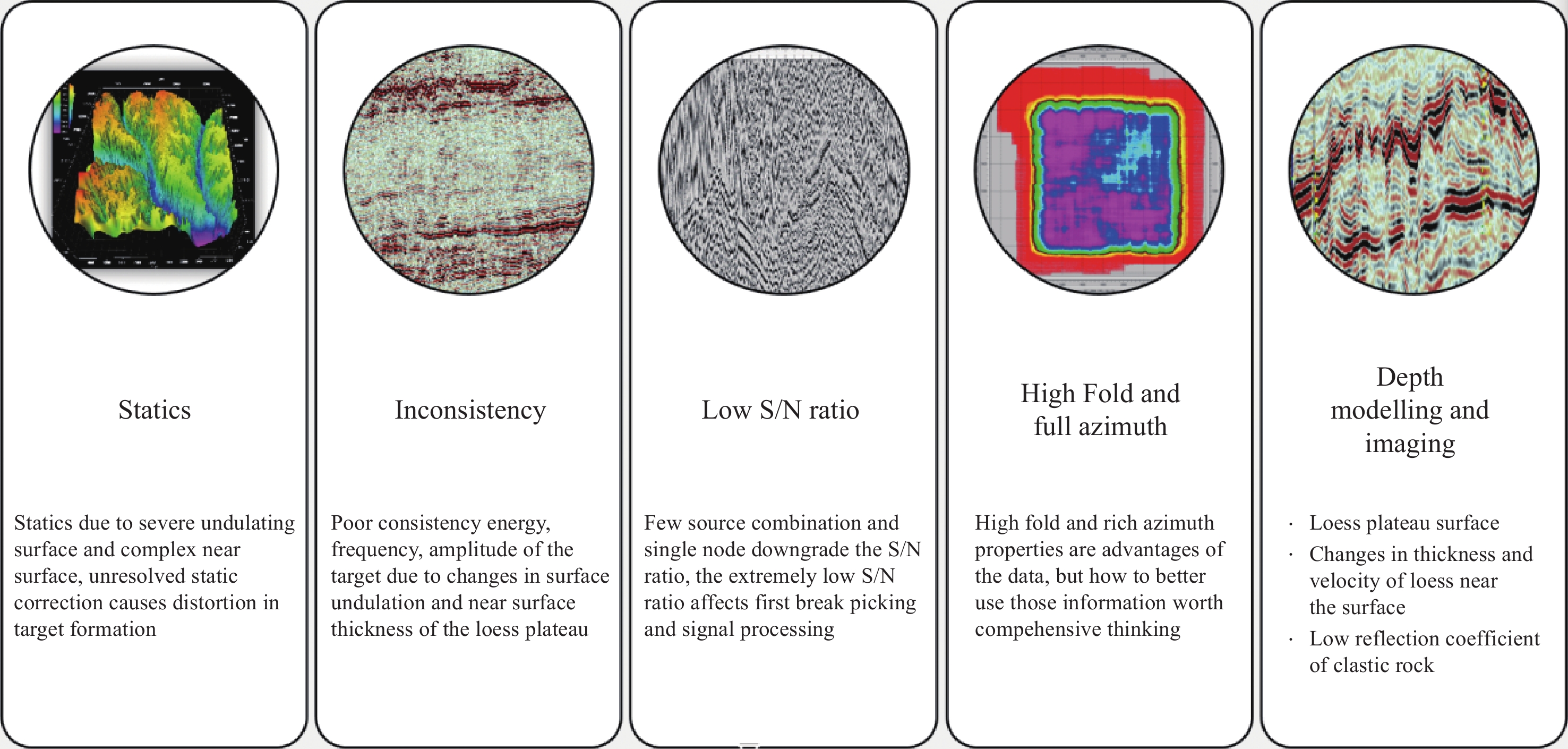
While the Ordos Basin is recognized for its substantial hydrocarbon exploration prospects, its rugged loess tableland terrain has rendered seismic exploration exceptionally challenging[1-3]. Persistent obstacles such as complex 3D survey planning, low signal-to-noise ratio raw data, inadequate near-surface velocity modeling, and imaging inaccuracy have long hindered the advancement of seismic exploration across this region. Through a problem-solving approach rooted in geological target analysis, this research systematically investigates the behavioral patterns of nodal seismometer-based high-density seismic acquisition in loess plateau. Tailored advancements in waveform enhancement and depth velocity modelling methodologies have been engineered. Field validations confirm that the optimized workflow demonstrates marked improvements in amplitude preservation and imaging resolution, offering novel insights for future reservoir characterization endeavors.
-
Keywords:
- Loess Plateau /
- acquisition /
- Low signal to noise ratio /
- data processing /
- depth modeling
摘要:鄂尔多斯盆地虽具备良好的油气勘探前景,但其复杂的黄土塬地貌特征使地震勘探面临诸多挑战[1-3]。三维观测系统设计困难、原始资料信噪比低、近地表速度建模精度不足及成像效果欠佳等问题长期制约着黄土塬区地震勘探发展。本研究面向地质目标需求,以面临实际问题为导向,系统剖析了黄土塬区节点地震仪高密度采集响应特征,形成了针对黄土塬区低信噪比资料的地震信号保幅处理与高精度深度速度建模方法技术,实现了黄土塬区整体地震资料处理解决方案优化升级。实际资料应用表明,优化后的技术流程在黄土塬区地震资料振幅保真度与成像分辨率方面提升显著,为后续深化地震资料处理及储层精细描述工作提供了新思路。
-
-
![]()
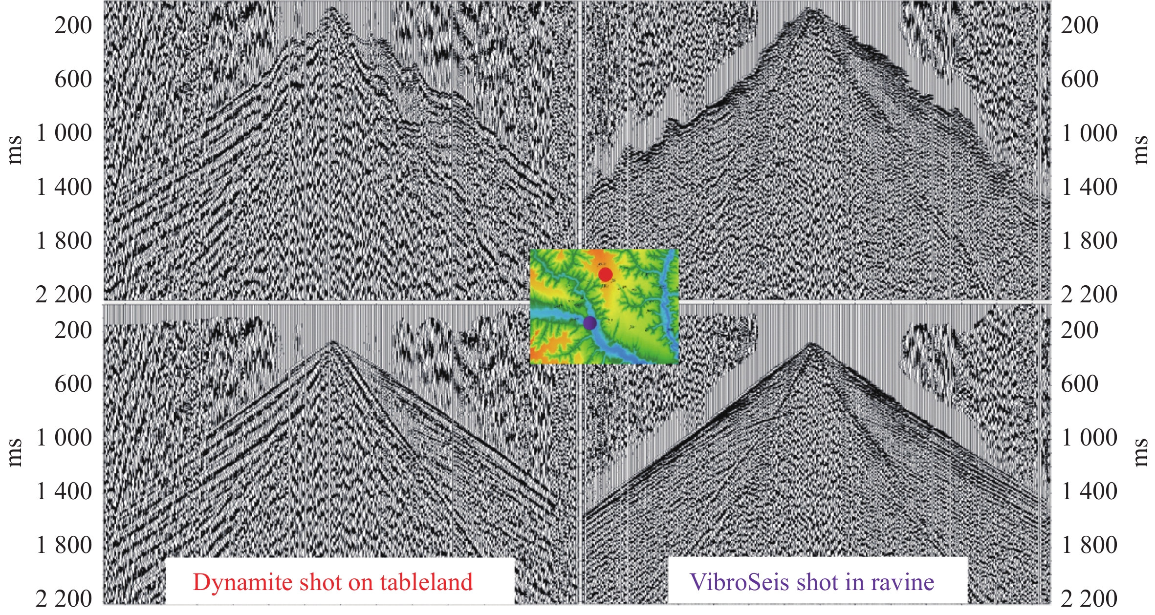
Figure 3. Raw shots of the acquired data: (left)-dynamite, (right) vibroseis acquisition
![]()
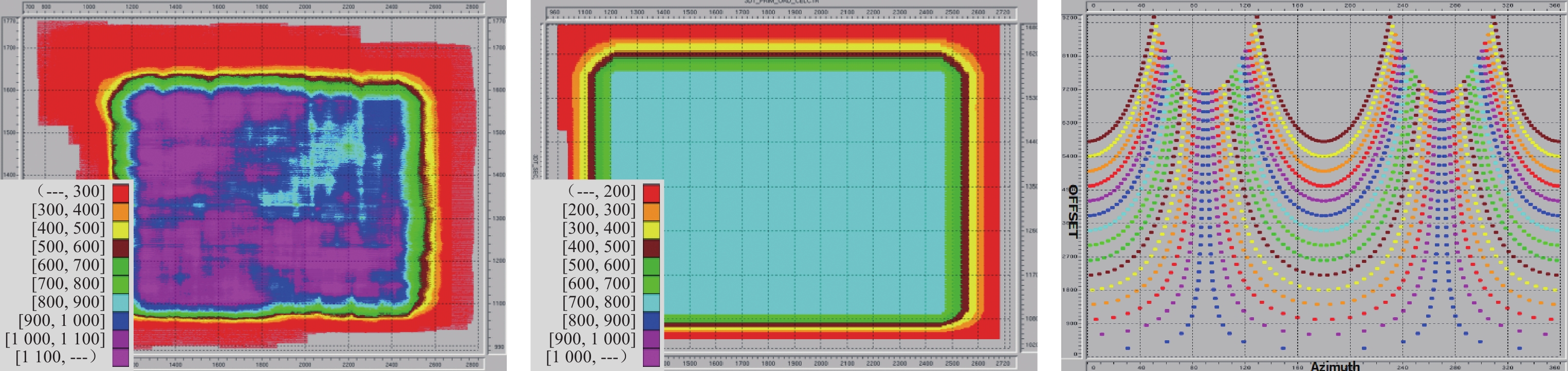
Figure 8. Fold of Coverage map and offset/azimuth preservation display after 5D regularization
![]()
Figure 10. ‘True surface’ PSDM imaging section (b) compared with legacy PSTM result (a)
![]()
Figure 11. AVO consistency analysis of Seismic gather and forward modelling gather (Well W3/W5)
Table 1 Acquisition Parameters
Acquisition Geometry 40L5S228T760F Fold of Coverage 760 Number of Traces 9120 Receiver Line Spacing 200 m Shot Line Spacing 120 m Trace Spacing 40 m Shot Point Spacing 80 m CMP Grid 20 m (Crossline) × 40 m (Inline) Min/Max Offset 28. 28 m/ 6037. 55 m  下载: 导出CSV
Table 2 Seismic-to-well mis-tie analysis
WELL Well Depth/m Imaging depth/m Mis-Tie/m Mis-tie (‰) W1 −2861.7 −2857.6 4.1 1.43 W2 −2817.9 −2813.2 4.7 1.68 W3 −2787.9 −2783.1 4.8 1.73 W4 −2763 −2759.9 3.1 1.13 W5 −2614.5 −2610.5 4 1.53 W6 −2605.1 −2599.8 5.3 2.03 W7 −2586.7 −2581.9 4.8 1.45
下载: 导出CSV
-
[1] 胡文瑞, 鄂尔多斯盆地油气勘探开发理论与技术[M]. 石油工业出版社, 北京, 2000: 1-15 HU W R. Theory and technology of oil and gas exploration and development in Ordos Basin[M]. Beijing: Petroleum Industry Press, 2000: 1-15. (in Chinese).
[2] YANG H, FU S T, WEI X S. Geology and exploration of oil and gas in Ordos Basin[J]. Applied Geophysics, 2004, 1(2): 103-109. DOI: 10.1007/s11770-004-0011-3.
[3] WANG D X. Progress challenges and technical requirements of 3D seismic exploration in the loess tableland of the Ordos Basin[J]. Geopysical Prospecting for Petroleum, 2024, 63(3): 517-534. DOI: 10.12431/issn.1000-1441.2024.63.03.001. (in Chinese).
[4] 程建远, 李宁, 侯世宁等, 黄土塬地震勘探技术发展现状综述[J]. 中国煤炭地质, 2009, 21(12): 73-76. CHENG J Y, LI N, HOU S N, et al. Development Status Overview of Seismic Prospecting Technology in Loess Tableland[J]. Coal Geology of China, 2009, 21(12): 73-76. (in Chinese).
[5] FU J H, DONG G D, ZHOU X P, et al. Research progress of petroleum geology and exploration technology in Ordos Basin[J]. China Petroleum Exploration, 2021, 26(3): 19-40. (in Chinese).
[6] 杜向东. 鄂尔多斯盆地黄土塬致密砂岩油气藏地震勘探技术新进展[C]//国际油气田勘探开发论坛, 2019: 4470. DU X D. New progress in seismic exploration technology for tight sandstone reservoirs in loess plateau of Ordos basin[C]//nternational Field Exploration and Development Conference, 2019: 4470(in Chinese).
[7] LIU B, DONG X G, et al. Key technology of high density seismic exploration in loess plateau of Southern Ordos Basin[J]. Science Technology and Engineering, 2023, 23(11): 4536-4543. DOI: 10.12404/j.issn.1671-1815.2023.23.11.04536. (in Chinese).
[8] WANG X Z, ZHANG L X, LIANG Q S, et al, Full-azimuth, high-density, 3D point-source/point-receiver seismic survey for shale gas exploration in a loess plateau: A case study from the Ordos basin[J]. First break, 2014, 32: 105-112.
[9] 王猛. 黄土塬地区中生界地震资料应用的问题和思考[J]. 中国石油大学胜利学院学报, 2018, 32(4): 9-15. WANG M, Problems and Thoughts on the application of Seismic Data in the Loess Plateau Area[J]. Journal of Shengli College China University of Petroleum, 2018, 32(4): 9-15. (in Chinese).
[10] HART D I, HOOTMAN B W, JACKSON A R. Modeling the seismic wavelet with model-based wavelet processing[C]//71st Ann. Internat. Mtg. , Soc. Expl. Geophysics, Expanded Abstracts, 2011, 1823-1826.
[11] SAGGAF M M, ROBINSON E A. A unified framework for the deconvolution of traces of nonwhite reflectivity[J]. Geophysics, 2000. 65 1660–1676.
[12] NGUYEN T. WINNETT R. Seismic interpolation by optimally matched Fourier components[C]//81st Annual International Meeting, SEG, Expanded Abstracts, 2011, 3085-3089.
[13] 王宁, 常艳粉, 胡亚东, 等. AI 初至拾取技术在黄土塬地震资料中的研究与应用[C]//第二界中国石油勘探学术年会, 2024: 558-561. WANG N, CHANG Y F, HU Y D, et al. Research and application of AI-based first-break picking technology in loess tableland, The 2nd Annual China Petroleum Geophysics Conference, 2024: 558-561. (in Chinese).
[14] XIA C L, DAI H T, LI G Q, et al. The calculation and application of a near surface Q value model based on dual-well micrologs for a loess plateau area[J]. Geophysical and Geochemical Exploration, 2024, 48(3): 698-704. (in Chinese).
[15] XU W, LIU H X, MI H G, et al. High-precision Q modeling and Q migration technology and its applications in loess plateau regions, Applied Geophysics, Vol. 21, 2024(4): 835−847.
[16] LIU J B, XIE Y G, WANG S W, et al. Field test study of cross-well seismic in the loess plateau area of Ordos Basin[J], IFEDC, 2024: 17041.
-
期刊类型引用(3)
1. 杨宇,黄杏. 胸部多层螺旋CT低剂量扫描的临床应用研究现状. 中国现代药物应用. 2023(17): 177-180 .  百度学术
百度学术
2. 潘兆鹏. 胸部多层螺旋CT低剂量扫描的研究现状及进展. 医疗装备. 2022(08): 192-194 . 百度学术
3. 龚芸. 不同迭代重组技术用于低剂量胸部CT平扫中的临床价值. 现代医用影像学. 2022(09): 1704-1706 . 百度学术
其他类型引用(1)


计量
- 文章访问数: 17
- HTML全文浏览量: 5
- PDF下载量: 1
- 被引次数: 4